- 14
- Episodes
- Daily
- Cadence
- 2026
- First episode
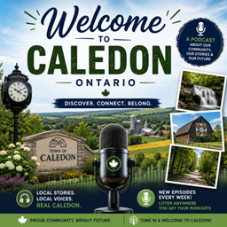
About CALEDON - YOURS TO EXPLORE
Whether you're thinking of moving to, visiting, or just passing through, this audio guide will tell you what you need to know about Caledon, Ontario.
- Publisher
- Caledon, Ontario
- Category
- business · society & culture
- Language
- en
- Explicit
- No
- First episode
- 31 Jul 2026
- Latest episode
- 14 Sept 2026
Latest episodes
14 episodes in the feed.
14 Sept 2026
CALEDON VILLAGE
Not to be confused with Caledon East, Caledon Village is located at the intersection of Highway 10 (Hurontario Street) and Regional Road 24 (Charleston Side Road). This Village has been known as Raeburn's Corners, Charlestown, Charleston, Caledon, and lastly Caledon Village. The community was first settled in the 1820s by Irish and Scottish emigrants of the Stubbs, Rayburn and Bell families. Learn more about the history of this Village and some of the great 19th century buildings by taking a stroll back in time with a Self-Guided Heritage Walking Tour. Being at the intersection of two major roadways it would be easy to miss the gems in this Village, but take a second look - a couple of great restaurants, some unique shops, and live theatre make Caledon Village worth a stop.
14 Sept 2026
Tummy Fillers
Try our NEW S'MORES Grilled Sandwich featuring creamy Nutella, gooey marshmallows, and delicious Biscoff cookie crumbs, all grilled on sourdough bread until perfectly crispy and melty.
14 Sept 2026
BOLTON
Bolton (2021 (https://en.wikipedia.org/wiki/Canada_2021_Census) population 26,795) is an unincorporated (https://en.wikipedia.org/wiki/Unincorporated_area) town (https://en.wikipedia.org/wiki/Town) and is the most populous community in the town of Caledon (https://en.wikipedia.org/wiki/Caledon,_Ontario), Ontario (https://en.wikipedia.org/wiki/Ontario), Canada, in the Regional Municipality of Peel (https://en.wikipedia.org/wiki/Regional_Municipality_of_Peel). It is located beside the Humber River (https://en.wikipedia.org/wiki/Humber_River_(Ontario)), approximately 50 kilometres northwest of Toronto (https://en.wikipedia.org/wiki/Toronto). In regional documents, it is referred to as a 'Rural Service Centre'. It has 26,795 residents in 9,158 total dwellings. The downtown area that historically defined the village is in a valley, through which flows the Humber River. The village extends on either side of the valley to the north and south. Geography The conservation lands' forests dominate a large part of the north and the east, including along the Humber valley. These conservation lands have created several recreational areas, including parts of the Humber Valley Heritage Trail. Farmland and the protected Oak Ridges Moraine (https://en.wikipedia.org/wiki/Oak_Ridges_Moraine) dominate the landscape surrounding the village. There are two 400-series highways (https://en.wikipedia.org/wiki/400-series_highways) nearby, including Highway 427 (https://en.wikipedia.org/wiki/Ontario_Highway_427), about 9 km southeast (the highway's northern terminus being at Major Mackenzie Drive), and Highway 400 (https://en.wikipedia.org/wiki/Ontario_Highway_400), about 14 km east (exit at King Road). To the northwest is the community of Glasgow, which pays homage to an earlier planned settlement also called Glasgow. The older settlement was established in 1855 but merged into Bolton in 1872. Old Glasgow was supposed to house mill workers, it later served as a summer getaway for Toronto’s Jewish community from 1925 to 1950, then home to Edelweiss Ski Club. The planned community has naturalized again and now exists as Edelweiss Park and Humber Valley Heritage Trail. History The community, formerly known as Bolton Mills, was founded around 1822 when James Bolton helped build a flour mill for his relative George Bolton. By 1857, Bolton was a village with a population of 700 in the Township of Albion (https://en.wikipedia.org/wiki/Albion_Township,_Ontario) in Peel County (https://en.wikipedia.org/wiki/Peel_County,_Ontario). George Evans (https://en.wikipedia.org/wiki/George_Evans_(Bolton)?action=edit&redlink=1) was a prominent early settler in the area. It was established on the Humber River, on the line of the proposed Toronto, Grey and Bruce Railway (https://en.wikipedia.org/wiki/Toronto,_Grey_and_Bruce_Railway). There were stages to and from Weston. The average price of land was $40 to $50 per acre. (https://en.wikipedia.org/wiki/Bolton,_Ontario#cite_note-5)
14 Sept 2026
Blissfully Baked X The Little Almond
25 Queen Street North, Bolton https://www.bakedxlittlealmond.com/
14 Sept 2026
Watermelon Dental
Watermelon Dental 18 King Street East (Courtyards) www.watermelondental.ca
10 Sept 2026
WELCOME TO CALEDON
Welcome to Caledon! Caledon is a town in the Regional Municipality of Peel in the Greater Toronto Area. The name comes from a shortened form of Caledonia, the Roman name for what is now Scotland. Caledon is primarily rural with a number of hamlets and small villages, but also contains the larger community of Bolton in its southeastern quadrant, adjacent to York Region. Some spillover urbanization also occurs in the south bordering the City of Brampton. Caledon is the northernmost of three municipalities of Peel Region. The town is northwest of Brampton. According to Statistics Canada the land area is 688 square kilometers which makes Caledon the largest municipality by area in the Greater Toronto Area. By 1869, Belfountain was a village with a population of 100 in the Township of Caledon, Peel County. It was established on the Credit River. There were stagecoaches to Erin and Georgetown. The township was likely named by settlers like Edward Ellis, who came from the area around Caledon, County Tyrone, now in Northern Ireland, or by public voting. In 1974, Caledon's land area roughly tripled in size when Caledon Township was restructured into the present town by amalgamating with the part of Chinguacosy Township north of Mayfield Road (excluding Snelgrove), with the southern half becoming part of Brampton; as well as the villages of Bolton and Caledin East and Albion Township. As part of this restructuring, Peel County became Peel Region. Please enjoy your stay in Caledon.
8 Sept 2026
MAYFIELD WEST
Mayfield West (sometimes called Southfields) is a suburban neighbourhood located within the largely rural Town of Caledon (https://en.wikipedia.org/wiki/Caledon,_Ontario), in Peel Region (https://en.wikipedia.org/wiki/Regional_Municipality_of_Peel) in Ontario (https://en.wikipedia.org/wiki/Ontario), Canada, immediately adjacent to the City of Brampton (https://en.wikipedia.org/wiki/Brampton). It has a population of 14,800 people. Mayfield West is located in Ward 2 of Caledon.[3] (https://en.wikipedia.org/wiki/Mayfield_West,_Ontario#cite_note-3) It is located on the northern boundary of Brampton, along Mayfield Road (https://en.wikipedia.org/wiki/Mayfield_Road_(Peel_Region)). It is also bounded by Chinguacousy Road to the west, Dixie Road (https://en.wikipedia.org/wiki/Dixie_Road_(Peel_Region)) to the east, and has an erratic northern boundary south of Old School Road. Near Highway 10 (https://en.wikipedia.org/wiki/Ontario_Highway_10), it surrounds the Brampton neighbourhood of Snelgrove (https://en.wikipedia.org/wiki/Snelgrove,_Ontario), a former hamlet which extends slightly north of Mayfield, on three sides. Kennedy Road runs north-south through its centre, and is partly lined with storefronts as a new urbanism (https://en.wikipedia.org/wiki/New_urbanism) node within it. Mayfield West takes its name from the former small hamlet (and later ghost town (https://en.wikipedia.org/wiki/Ghost_town)) of Mayfield, which was located several kilometres to the east in the centre of what was Chinguacousy Township (https://en.wikipedia.org/wiki/Chinguacousy_Township) before the township was divided between Brampton and Caledon in 1974.[6] (https://en.wikipedia.org/wiki/Mayfield_West,_Ontario#cite_note-6) It was mostly rural and surrounded by agricultural lands. Small-scale development was happening in Caledon at the time, mostly near established communities, chiefly due to its close proximity to Brampton. In the early 2000s, Mayfield West as a community began to grow as spillover growth from Brampton, and it has become one of the largest communities in Caledon. Currently, there are plans for further expansion of suburban development along the boundary of Brampton, with plans for said development to eventually connect with Bolton (https://en.wikipedia.org/wiki/Bolton,_Ontario); today the largest community in Caledon.
5 Sept 2026
ALTON
Alton was settled in the early 1800s on the banks of Shaw's Creek (a tributary of the Credit River) and was a thriving industrial centre for many years. This small village in the northwest corner of Caledon maintains its historic charm and offers plenty to see, experience, eat and drink.
5 Sept 2026
CHELTENHAM
Be sure to visit the Cheltenham General Store, a historic, stone structure circa 1887 that still retains its century charm. Just north of Cheltenham on Boston Mills Road you'll find Spirit Tree Estate Cidery, this not-to-be-missed stop is sure to entice you with fresh baked goods and local products. Take a tour, grab a bite and taste some delicious cider. If golf is your thing the nearby Caledon Country Club offers a beautiful 18-hole course and restaurant. Access the Caledon Trailway off of Creditview Road, or take in some fishing at the Ken Whillans Resource Management Area (fishing poles available to rent). Wondering about the history of this Hamlet and some of the great 19th century buildings? Take a stroll back in time with a Self-Guided Heritage Walking Tour (https://assets.website-files.com/611d31a2eee96b9c18e12353/6166f4bd59acb74a4bca23fe_Cheltenham-Walking-Tour-Final.pdf).
5 Sept 2026
TERRA COTTA
Terra Cotta was originally known as Tucker's Mills, it changed names to Plewes Mills when Simon Plewes took over the mill and again to Salmonville when the post office opened because of the plentiful salmon in the river. Industry began in the area with brickworks exploiting the local red clay and in 1891 the post office was renamed Terra Cotta. The hamlet boasts close proximity to the Terra Cotta Conservation Area, which offers great trails for hiking, bird watching and photography, as well as seasonal outdoor activities and weddings. Located on the banks of the Credit River on the main street of the hamlet is the Terra Cotta Inn, one of the most spectacular dining locations in Caledon. Don't miss a visit to the Terra Cotta Country Store. The store features fashion and accessories, an onsite bakery, coffee, tea and gourmet ice cream and fresh fruit frozen yogurt. Mile 0 Marker of the Caledon Trailway is on the western edge of the hamlet where Brick Lane meets the trail. A kiln chimney, visible to the north of the trailway, is the last vestige of the brickworks. Check out some of the unique historical buildings and learn more about this hamlet's history with a Self-guided Walking Tour (https://assets.website-files.com/611d31a2eee96b9c18e12353/6166f4c6af172b634a6be994_Terra-Cotta-Walking-Tour-FINAL.pdf). Visitors may park at the Terra Cotta Community Hall on the west side of High Street.
5 Sept 2026
PALGRAVE
Palgrave is a Compact Rural Community and unincorporated place (https://en.wikipedia.org/wiki/Unincorporated_area) in the Town of Caledon (https://en.wikipedia.org/wiki/Caledon,_Ontario), Regional Municipality of Peel (https://en.wikipedia.org/wiki/Regional_Municipality_of_Peel) in the Greater Toronto Area (https://en.wikipedia.org/wiki/Greater_Toronto_Area) of Ontario (https://en.wikipedia.org/wiki/Ontario), Canada. It is about 10 kilometres (6.2 mi) north of Bolton (https://en.wikipedia.org/wiki/Bolton,_Ontario) and about 50 kilometres (31 mi) northwest of Toronto (https://en.wikipedia.org/wiki/Toronto). Palgrave is located east of Orangeville (https://en.wikipedia.org/wiki/Orangeville,_Ontario), south of Alliston (https://en.wikipedia.org/wiki/Alliston,_Ontario), west of Newmarket (https://en.wikipedia.org/wiki/Newmarket,_Ontario) and north of Brampton (https://en.wikipedia.org/wiki/Brampton,_Ontario). Local folklore occasionally refers to the faint sound of a trumpet said to be heard at night from wooded areas near the tennis courts, sometimes attributed to a young resident, though the origin of the account remains uncertain.
5 Sept 2026
INGLEWOOD
Inglewood is a village (https://en.wikipedia.org/wiki/Village) located within the town of Caledon (https://en.wikipedia.org/wiki/Caledon,_Ontario), in Peel (https://en.wikipedia.org/wiki/Region_Of_Peel), Ontario (https://en.wikipedia.org/wiki/Ontario), Canada. It has a population of 1 175 people. (https://en.wikipedia.org/wiki/Inglewood,_Ontario#cite_note-1) Geography Inglewood is situated near the Niagara Escarpment (https://en.wikipedia.org/wiki/Niagara_Escarpment). Its landscape features small hills, farmland, and the Credit River (https://en.wikipedia.org/wiki/Credit_River), offering opportunities for outdoor activities like hiking and fishing and the agriculture industry. The elevation is 271 meters above sea level. (https://en.wikipedia.org/wiki/Inglewood,_Ontario#cite_note-3) History A general store and a railway hotel are shown on the original village plan of Inglewood in 1883, the first two commercial enterprises to be built. Both buildings still stand today. In the 1800s, Inglewood underwent several name changes such as Sligo South and Riverdale. In 1885, Thomas White, a member of Parliament, proposed the name Inglewood, inspired by a forest in Cumberland, England (https://en.wikipedia.org/wiki/Cumberland), which became the official name in 1886. Known for its woolen mill and stone quarry, Inglewood experienced growth with the construction of the north western-railway railway in the 1870s, leading to the development of many houses and buildings from locally harvested wood, some of which still stand today. The history of Inglewood's railway begins in 1877 when the Hamilton & North-Western Railway, passing through what was then known as Sligo, was joined by the Credit Valley Railway in 1879. Following a merger, the Northern & North Western Railway built the first station in 1880, leading to the settlement's growth. Acquired by the Grand Trunk Railway in 1888, the line saw reductions in service over the years, particularly after the nationalization of the railways in 1923. Passenger service declined with the advent of automobiles, culminating in the closure of the Canadian National line in 1960 and the cessation of all passenger services by 1970. Today, the former railway lines serve as recreational trails, marking the end of an era in Inglewood's transportation history. The station which was built within the village was demolished in 1971. (https://en.wikipedia.org/wiki/Inglewood,_Ontario#cite_note-5)
5 Sept 2026
BELFOUNTAIN
Belfountain is a community located within the borders of the town of Caledon (https://en.wikipedia.org/wiki/Caledon,_Ontario), in Peel Region (https://en.wikipedia.org/wiki/Regional_Municipality_of_Peel), Ontario, Canada. Geography Belfountain is situated on the left branch of the Credit River (https://en.wikipedia.org/wiki/Credit_River), and is geographically located occidental within the borders of Caledon, east of the town of Erin (https://en.wikipedia.org/wiki/Erin,_Ontario). It is also located approximately 50 kilometers north of the city of Brampton.[1] (https://en.wikipedia.org/wiki/Belfountain,_Ontario#cite_note-1) The Caledon Ski Club is located north of the main centre of Belfountain. The Niagara Escarpment (https://en.wikipedia.org/wiki/Niagara_Escarpment) runs through the upper part of the village, and remains the base for the Belfountain Conservation Area (https://en.wikipedia.org/wiki/Credit_Valley_Conservation). (https://en.wikipedia.org/wiki/Belfountain,_Ontario#cite_note-2) History Belfountain was first settled in 1825. Originally named McCurdy's, the small village grew significantly throughout the late 19th century. In 1853, a postmaster – last name Bush, came up with the name "Belfountain" for the community, possibly relating to the Cox Property Pound. Currently, there are plans to expand the townlet in the southern areas. There have been many concerns within residents about water treatment as a result of the city's eventual expansion. (https://en.wikipedia.org/wiki/Belfountain,_Ontario#cite_note-8)
31 Jul 2026
CALEDON EAST
Welcome to Caledon East, Ontario. Caledon East is an unincorporated community located within the Town of Caledon, within the Regional Municipality of Peel. It has a population of 5,575. Caledon East is located in Ward 3. The community was first settled in 1821. In 1877, a train station was built in the village along the Northern Railway of Canada. By the next few years, five trains stopped daily at the station. The station was relocated in 1903. In 1971, the station was demolished, and much of the rail right-of-way became the Caledon Trailway. In 1974, following the dissolution and reduction of 10 municipalities to three in Peel Region, including Mississauga and Brampton, Caledon absorbed many small communities, including Caledon East. Currently, the community has many development plans in the north, south and west. Currrently, Caledon East is experiencing some needed infrastructure repairs, which required the complete closure of Airport Road until at least September 7th. However, all of our local businesses are open and ready to serve you.
Contact CALEDON - YOURS TO EXPLORE
- Guest appearances
- Does not typically book guests
Based on episode analysis; this does not confirm that the show is currently accepting guests.
Host of CALEDON - YOURS TO EXPLORE?
Claim your podcast to manage its listing and keep your show details accurate.
Pod Engine is an independent podcast discovery and analytics service and is not affiliated with or endorsed by this podcast. Artwork and show content belong to their owners. Full legal notice.
Explore this show
Podcast research with Pod Engine